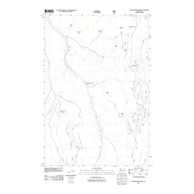
2011 Map of Eckler Mountain
USGS Topo · Published 2011About this map
The North Fork Touchet River carves through this corner of the Blue Mountains, where the landscape is defined by a dense network of gulches and ridges. Established rural outposts like L Greiner Ranch, E Watts Ranch, and J Able Ranch dot the valley floor, showing the persistent ranching footprint in Columbia County. Along the eastern heights, Skyline Dr and the Kendall Skyline Rd follow the high ground near Mountain Top and Eckler Mountain, providing access to the Stockade Spring Campground. Water management and recreational sites are prominent, including the Huckleberry Mountain Reservoir Dam and the isolated Camp Mead. The map also captures several natural landmarks such as Hompegg Falls and the deep Spoonamore Canyon, alongside numerous seasonal drainages like Jim Creek and Spangler Creek.
Find a feature on this map
43 named features on this map. Tap any name to fly to it.
Don’t see what you’re looking for? This feature index may not catch every label — zoom into the map to look around manually.
Map Details
Editions of this 2011 Eckler Mountain Map
This is the sole edition of this map. No revisions or reprints were ever made.
Other maps of this area

1937 · Pomeroy
USGS Topo · 1:96,000

1942 · Pomeroy
USGS Topo · 1:125,000

1955 · Pullman
USGS Topo · 1:250,000

1958 · Pullman
USGS Topo · 1:250,000
1967 · Robinette Mtn.
USGS Topo · 1:24,000

1967 · Hopkins Ridge
USGS Topo · 1:24,000

1967 · Cahill Mtn
USGS Topo · 1:24,000

1967 · Oregon Butte
USGS Topo · 1:24,000
1967 · Dayton
USGS Topo · 1:24,000
1967 · Panjab Creek
USGS Topo · 1:24,000