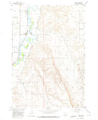
1956 Map of Edgar
USGS Topo · Published 1976About this map
The confluence of the Yellowstone River and the Clarks Fork forms the geographic heart of this mid-century survey, which documents a landscape defined by industrial irrigation and rail logistics. The settlement of Edgar serves as a local hub, anchored by its Grain Elevators and a strategic junction of the Chicago Burlington and Quincy and Northern Pacific railroads.
Find a feature on this map
19 named features on this map. Tap any name to fly to it.
Don’t see what you’re looking for? This feature index may not catch every label — zoom into the map to look around manually.
Map Details
Editions of this 1956 Edgar Map
2 editions found
Other maps of this area

1954 · Billings
USGS Topo · 1:250,000

1956 · Bridger
USGS Topo · 1:24,000

1956 · Silesia
USGS Topo · 1:24,000

1956 · Fromberg
USGS Topo · 1:24,000

1956 · Edgar
USGS Topo · 1:24,000
1956 · Montaqua
USGS Topo · 1:24,000

1957 · Billings
USGS Topo · 1:250,000

1958 · Billings
USGS Topo · 1:250,000

1967 · Section House Draw
USGS Topo · 1:24,000

1967 · Bluewater
USGS Topo · 1:24,000