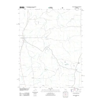
2012 Map of Edgar Springs
USGS Topo · Published 2012About this map
Edgar Springs serves as the primary hub for this portion of Phelps County, situated along the north-south axis of the local road network. The landscape is defined by the winding paths of Little Piney Creek and Black Oak Creek, which have shaped the rural development of the area. This 2012 survey reveals a community deeply rooted in its local history, evidenced by a high density of family and community burial grounds including Weber Cemetery, Renaud Cemetery, and Mitchell Cemetery. In the eastern section, the small settlements of Lenox and North Lenox sit near the headwaters of Bean Creek, while further south, the Tealwood Dam holds back the waters of Lake Tealwood. The road names themselves, such as Stave Mill Rd and Black Cemetery Rd, provide insight into the historical industry and landmarks that have organized life in this Missouri countryside for generations.
Find a feature on this map
50 named features on this map. Tap any name to fly to it.
Don’t see what you’re looking for? This feature index may not catch every label — zoom into the map to look around manually.
Map Details
Editions of this 2012 Edgar Springs Map
This is the sole edition of this map. No revisions or reprints were ever made.
Other maps of this area

1912 · Rolla
USGS Topo · 1:62,500

1928 · Meramec Spring
USGS Topo · 1:62,500

1937 · Edgar Springs
USGS Topo · 1:48,000

1941 · Salem
USGS Topo · 1:62,500

1945 · Salem
USGS Topo · 1:62,500

1945 · Edgar Springs
USGS Topo · 1:62,500

1949 · Rolla
USGS Topo · 1:250,000

1949 · Meramec Spring
USGS Topo · 1:62,500
1950 · Kaintuck Hollow
USGS Topo · 1:24,000
1950 · Yancy Mills
USGS Topo · 1:24,000