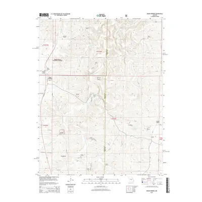
2015 Map of Edgar Springs
USGS Topo · Published 2015About this map
Edgar Springs sits as a primary settlement along the western edge of this Ozark plateau landscape, where the town’s grid meets the expansive Mark Twain National Forest. The geography is defined by a series of narrow valleys and winding creeks, including Little Piney Cr and Bean Cr, which carve through the terrain. This 2015 data illustrates a region heavily marked by its local genealogy, featuring a dense distribution of family-named burial grounds such as Hall/Heavin Cemetery, Jocoy Cemetery, and Renaud Cemetery. Small communities like Craddock and Lenox are linked by a complex network of county roads, showing the persistent rural settlement pattern of eastern Phelps and western Dent counties. To the east, Lake Tealwood and North Lenox provide additional points of interest within the predominantly forested and agricultural land.
Find a feature on this map
67 named features on this map. Tap any name to fly to it.
Don’t see what you’re looking for? This feature index may not catch every label — zoom into the map to look around manually.
Map Details
Editions of this 2015 Edgar Springs Map
This is the sole edition of this map. No revisions or reprints were ever made.
Other maps of this area

1912 · Rolla
USGS Topo · 1:62,500

1928 · Meramec Spring
USGS Topo · 1:62,500

1937 · Edgar Springs
USGS Topo · 1:48,000

1941 · Salem
USGS Topo · 1:62,500

1945 · Salem
USGS Topo · 1:62,500

1945 · Edgar Springs
USGS Topo · 1:62,500

1949 · Rolla
USGS Topo · 1:250,000

1949 · Meramec Spring
USGS Topo · 1:62,500
1950 · Kaintuck Hollow
USGS Topo · 1:24,000
1950 · Yancy Mills
USGS Topo · 1:24,000