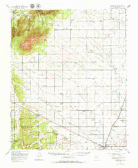
1956 Map of Edgewood
USGS Topo · Published 1979About this map
The San Pedro Mountains and Oro Quay Peak dominate the northwestern corner of this mid-century survey, giving way to an expansive network of arroyos and homesteads across the Estancia Basin. The landscape is defined by its ranching history, with numerous family-named landmarks such as the J Yates Ranch, King Bros Ranch, and P Simmons Place scattered across the high plains. An Old Railroad Grade and a prominent Telephone Line trace the movement of infrastructure through the region, while the Airfield Beacon in the southeast indicates the growing importance of aviation in the post-war era. Genealogists will find significant value in the documentation of the Mtn View Cemetery and Mtn Valley Cemetery, alongside established settlements like San Pedro, Cedar Grove, and Edgewood.
Find a feature on this map
59 named features on this map. Tap any name to fly to it.
Don’t see what you’re looking for? This feature index may not catch every label — zoom into the map to look around manually.
Map Details
Editions of this 1956 Edgewood Map
3 editions found

Other maps of this area

1892 · San Pedro
USGS Topo · 1:125,000

1894 · Lamy
USGS Topo · 1:125,000

1917 · Estancia
USGS Topo · 1:125,000

1954 · Chilili
USGS Topo · 1:24,000

1954 · Sandia Park
USGS Topo · 1:24,000

1954 · San Pedro
USGS Topo · 1:24,000

1954 · Sedillo
USGS Topo · 1:24,000

1954 · Hagan
USGS Topo · 1:24,000

1954 · Escabosa
USGS Topo · 1:24,000

1954 · Edgewood
USGS Topo · 1:24,000