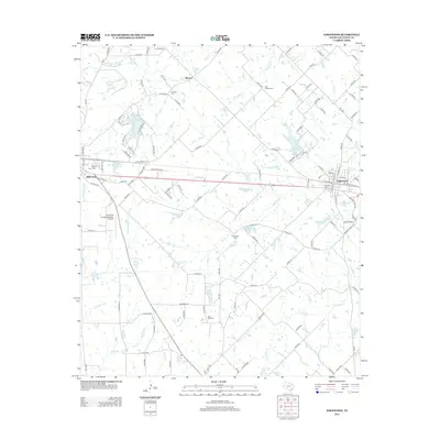
2012 Map of Edgewood
USGS Topo · Published 2012About this map
Wills Point and Edgewood anchor this Van Zandt County landscape, connected by a dense network of county roads and rail lines that define the local transport pattern. The terrain is intricately carved by numerous watercourses, including Giladon Cr, Allen Cr, and McEnturff Cr, which feed into several private and municipal water bodies such as Edgewood City Lake and the Fin and Feathers Club Lake. This era shows a community structured around its heritage sites, with numerous burial grounds scattered across the countryside, including Woodall Cem, Rock Hill Cem, and Ellis Chapel Cem. The inclusion of the Van Zandt County Regional Airport south of Wills Point highlights the integration of modern infrastructure within a traditional rural framework. Small settlements like Elwood remain visible along the northern reaches of the survey, reflecting the persistent small-town geography of the Texas blackland prairies.
Find a feature on this map
129 named features on this map. Tap any name to fly to it.
Don’t see what you’re looking for? This feature index may not catch every label — zoom into the map to look around manually.
Map Details
Editions of this 2012 Edgewood Map
This is the sole edition of this map. No revisions or reprints were ever made.
Other maps of this area

1954 · Dallas
USGS Topo · 1:250,000

1956 · Tyler
USGS Topo · 1:250,000

1956 · Quinlan
USGS Topo · 1:62,500

1956 · Emory
USGS Topo · 1:62,500

1958 · Dallas
USGS Topo · 1:250,000

1962 · Myrtle Springs
USGS Topo · 1:24,000

1962 · Cedarvale
USGS Topo · 1:24,000

1962 · Wills Point
USGS Topo · 1:24,000
1962 · Canton
USGS Topo · 1:24,000
1962 · Edgewood
USGS Topo · 1:24,000