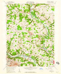
1958 Map of Edinburg
USGS Topo · Published 1959About this map
The confluence of the Shenango River and the Mahoning River dominates this late-1950s landscape in Lawrence County, where a complex network of industrial transport reflects the era's heavy manufacturing focus. The region is interlaced with major rail lines including the Pennsylvania Railroad, Erie Railroad, and the Baltimore and Ohio Railroad. These tracks serve a series of settlements from Pulaski in the north to the industrial corridor at Hillsville and Edinburg in the south.
Find a feature on this map
52 named features on this map. Tap any name to fly to it.
Don’t see what you’re looking for? This feature index may not catch every label — zoom into the map to look around manually.
Map Details
Editions of this 1958 Edinburg Map
4 editions found
Other maps of this area

1902 · New Castle
USGS Topo · 1:62,500

1904 · Newcastle
USGS Topo · 1:62,500

1905 · Neshannock
USGS Topo · 1:62,500

1906 · Youngstown
USGS Topo · 1:62,500

1907 · Neshannock
USGS Topo · 1:62,500

1907 · Columbiana
USGS Topo · 1:62,500

1908 · Youngstown
USGS Topo · 1:62,500

1909 · Columbiana
USGS Topo · 1:62,500

1950 · Cleveland
USGS Topo · 1:250,000

1951 · Canton
USGS Topo · 1:250,000
Featured Places
- Pulaski Township, PA
- Frizzleburg, Pulaski Township
- Neshannock Township, PA
- Edinburg, Mahoning Township
- North Edinburg, Mahoning Township