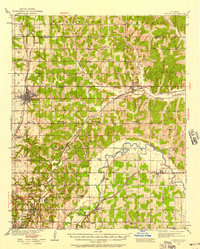
1935 Map of Edmond
USGS Topo · Published 1958About this map
Edmond stands as a central hub in this mid-1930s landscape, serving as a vital intersection for the Atchison Topeka and Santa Fe railroad and regional road networks. The survey captures a high density of rural educational and religious sites, such as Mt Zion Sch, Rose Hill Ch, and Redtop Sch, illustrating the structured community life of central Oklahoma before post-war suburban expansion. Along the southern edge, the map reveals the early footprint of Oklahoma City, including the recreational grounds of Lincoln Park and the specialized Airway Beacon for early aviation navigation.
Find a feature on this map
67 named features on this map. Tap any name to fly to it.
Don’t see what you’re looking for? This feature index may not catch every label — zoom into the map to look around manually.
Map Details
Editions of this 1935 Edmond Map
2 editions found

Other maps of this area

1892 · Moore
USGS Topo · 1:62,500

1892 · Guthrie
USGS Topo · 1:62,500

1892 · Edmond
USGS Topo · 1:62,500

1892 · Kingfisher
USGS Topo · 1:125,000

1893 · Oklahoma City
USGS Topo · 1:62,500

1895 · Kingfisher
USGS Topo · 1:125,000

1898 · Purcell
USGS Topo · 1:125,000

1904 · Chickasha
USGS Topo · 1:125,000

1909 · Luther
USGS Topo · 1:62,500

1909 · Perkins
USGS Topo · 1:62,500