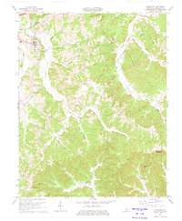
1974 Map of Edmonton
USGS Topo · Published 1975About this map
Edmonton serves as the focal point of this Metcalfe County landscape, situated where the South Fork Barren River meets numerous smaller tributaries like Skaggs Creek. The map documents a rural environment defined by narrow ridges and deep hollows, such as Mosby Ridge and England Hollow, where petroleum and gas extraction were active as evidenced by various Oil Wells and a Gas Well. The settlement pattern follows these high ridges, with small communities and centers of local life anchored by landmarks like Winfrey Chapel and Beech Grove Ch.
Find a feature on this map
67 named features on this map. Tap any name to fly to it.
Don’t see what you’re looking for? This feature index may not catch every label — zoom into the map to look around manually.
Map Details
Editions of this 1974 Edmonton Map
2 editions found
Other maps of this area

1953 · Gradyville
USGS Topo · 1:24,000

1953 · Sulphur Well
USGS Topo · 1:24,000

1953 · Sulphur Lick
USGS Topo · 1:24,000

1953 · Breeding
USGS Topo · 1:24,000

1953 · Waterview
USGS Topo · 1:24,000

1953 · Edmonton
USGS Topo · 1:24,000

1953 · Summer Shade
USGS Topo · 1:24,000

1953 · Dubre
USGS Topo · 1:24,000

1953 · East Fork
USGS Topo · 1:24,000

1956 · Corbin
USGS Topo · 1:250,000