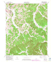
1974 Map of Edmonton
USGS Topo · Published 1983About this map
Edmonton serves as the focal point of this Metcalfe County landscape, where the Toll Road Cumberland Pkwy and KY 80 intersect near the town center. The topography is defined by the winding course of the Little Barren River and its numerous tributaries, including the South Fork Little Barren River. Rural life in the mid-20th century is evidenced by a network of country churches such as Douglas Ch, Grace Union Ch, and Society Hill Ch, alongside several cemeteries that mark the community's genealogy. Natural resource extraction is visible through scattered Oil Wells and a Gas Well in the central valleys. Notable landmarks include the Lone Star Lookout Tower on a southern ridge and the Moore Spring (Subtle PO) settlement to the east, illustrating the persistence of small rural post office hubs amidst the rugged Kentucky interior.
Find a feature on this map
46 named features on this map. Tap any name to fly to it.
Don’t see what you’re looking for? This feature index may not catch every label — zoom into the map to look around manually.
Map Details
Editions of this 1974 Edmonton Map
2 editions found
Other maps of this area

1953 · Gradyville
USGS Topo · 1:24,000

1953 · Sulphur Well
USGS Topo · 1:24,000

1953 · Sulphur Lick
USGS Topo · 1:24,000

1953 · Breeding
USGS Topo · 1:24,000

1953 · Waterview
USGS Topo · 1:24,000

1953 · Edmonton
USGS Topo · 1:24,000

1953 · Summer Shade
USGS Topo · 1:24,000

1953 · Dubre
USGS Topo · 1:24,000

1953 · East Fork
USGS Topo · 1:24,000

1956 · Corbin
USGS Topo · 1:250,000