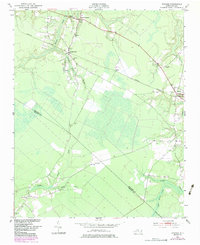
1950 Map of Edward
USGS Topo · Published 1983About this map
The coastal plain of Beaufort County and Craven County is defined by the slow-moving waters of Blounts Creek and Durham Creek, which carve through a landscape of low-lying wetlands and timbered tracts. The area around Edward serves as a focal point for the Norfolk Southern railroad, illustrating the importance of rail transit for moving resources through this corner of North Carolina. Small rural clusters and post offices, such as Blounts Creek (PO) and Coxs Crossroads, reveal a pattern of settlement tied closely to the intersection of early farm roads and drainage basins.
Find a feature on this map
25 named features on this map. Tap any name to fly to it.
Don’t see what you’re looking for? This feature index may not catch every label — zoom into the map to look around manually.
Map Details
Editions of this 1950 Edward Map
Other maps of this area

1901 · New Bern
USGS Topo · 1:62,500

1902 · Vanceboro
USGS Topo · 1:62,500

1903 · New Bern
USGS Topo · 1:62,500

1904 · Vanceboro
USGS Topo · 1:62,500

1905 · Vanceboro
USGS Topo · 1:62,500

1950 · Aurora
USGS Topo · 1:24,000

1950 · Edward
USGS Topo · 1:24,000

1951 · Bath
USGS Topo · 1:24,000

1951 · Hackney
USGS Topo · 1:24,000

1953 · Blounts Bay
USGS Topo · 1:24,000