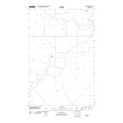
2010 Map of Effie SE
USGS Topo · Published 2010About this map
The Fredheim Norwegian Church Cemetery serves as a central landmark in this portion of Itasca County, reflecting the Scandinavian heritage that helped settle the northern Minnesota woods. The landscape is defined by the winding course of the Big Fork River, which snakes across the quadrangle through a low-lying region of timber and wetlands. The drainage pattern here is complex, with Coon Creek and Swine Creek feeding into larger water bodies like Grass Lake and Busties Lake. Rising above the surrounding lowlands, the Harrington Hills provide the area's most significant topographic relief. The map reveals a transition from these wilder river corridors to a structured grid of rural roads, including County Hwy-229 and Priem Rd, illustrating how early 21st-century infrastructure navigated the challenging terrain of the Big Fork valley.
Find a feature on this map
18 named features on this map. Tap any name to fly to it.
Don’t see what you’re looking for? This feature index may not catch every label — zoom into the map to look around manually.
Map Details
Editions of this 2010 Effie SE Map
This is the sole edition of this map. No revisions or reprints were ever made.
Other maps of this area

1919 · Release
USGS Topo · 1:62,500

1919 · Marcell
USGS Topo · 1:62,500

1943 · Release
USGS Topo · 1:62,500

1954 · Hibbing
USGS Topo · 1:250,000

1957 · Hibbing
USGS Topo · 1:250,000

1958 · Hibbing
USGS Topo · 1:250,000

1964 · Hibbing
USGS Topo · 1:250,000

1970 · Coon Lake
USGS Topo · 1:24,000
1970 · Anderson Lake
USGS Topo · 1:24,000
1970 · Deer Lake NW
USGS Topo · 1:24,000