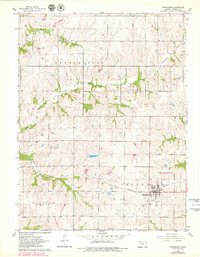
1961 Map of Effingham
USGS Topo · Published 1979About this map
Effingham serves as the primary hub for this portion of Atchison County, situated at the crossroads of the Missouri Pacific railroad and regional roadways. The landscape is defined by the drainage basins of Grasshopper Creek, Little Grasshopper Creek, and Brush Creek, where agricultural land use meets the natural riparian corridors. This 1961 field-checked survey, updated in the late 1970s, reveals a rural infrastructure supported by local aviation at the Strauss Landing Strip and small-scale industry at a Gravel Pit. Genealogists and local historians will find several burial grounds documented, including Brush Creek Cem and Forest Grove Cem, along with an additional unnamed Cem south of the main town site. Water management is evidenced by Figge Lake and the Sewage Disposal Ponds, reflecting the civic development of the era.
Find a feature on this map
19 named features on this map. Tap any name to fly to it.
Don’t see what you’re looking for? This feature index may not catch every label — zoom into the map to look around manually.
Map Details
Editions of this 1961 Effingham Map
2 editions found
Other maps of this area

1885 · Atchison
USGS Topo · 1:125,000

1886 · Oskaloosa
USGS Topo · 1:125,000

1888 · Oskaloosa
USGS Topo · 1:125,000

1888 · Atchison
USGS Topo · 1:125,000

1888 · Hiawatha
USGS Topo · 1:125,000

1889 · Topeka
USGS Topo · 1:125,000

1893 · Atchison
USGS Topo · 1:125,000

1894 · Oskaloosa
USGS Topo · 1:125,000

1894 · Topeka
USGS Topo · 1:125,000

1894 · Hiawatha
USGS Topo · 1:125,000