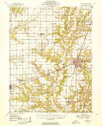
1951 Map of Effingham
USGS Topo · Published 1951About this map
Effingham serves as the bustling regional hub on this mid-century survey, positioned at the junction of the Pennsylvania and Illinois Central railroads. The map reveals a transition from the urban density of the city center—complete with its Radio Tower WCRA, Fairground, and Golf Club—to the fertile agricultural stretches of Douglas and Summit townships. To the west, the city of Altamont is anchored by the Altamont Reservoir and the Baltimore And Ohio line, illustrating the critical role of rail infrastructure in Southern Illinois during this era.
Find a feature on this map
94 named features on this map. Tap any name to fly to it.
Don’t see what you’re looking for? This feature index may not catch every label — zoom into the map to look around manually.
Map Details
Editions of this 1951 Effingham Map
2 editions found

Other maps of this area

1934 · Mattoon
USGS Topo · 1:62,500

1937 · Mattoon
USGS Topo · 1:62,500

1941 · St. Elmo
USGS Topo · 1:62,500

1942 · Shelbyville
USGS Topo · 1:62,500

1945 · St. Elmo
USGS Topo · 1:62,500

1945 · Kinmundy
USGS Topo · 1:62,500

1946 · Shelbyville
USGS Topo · 1:62,500

1947 · Kinmundy
USGS Topo · 1:62,500

1947 · Stewardson
USGS Topo · 1:62,500

1949 · Stewardson
USGS Topo · 1:62,500