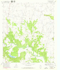
1956 Map of Eidson Lake
USGS Topo · Published 1979About this map
The Leon River winds through this central Texas landscape, which is marked by the transition from upland ridges to fertile bottomlands. In the mid-1950s, the area's rural character was defined by a network of creeks and branches, including Mesquite Creek, Indian Creek, and Gum Branch. Local community life is anchored by landmarks like Providence Ch and the Massingill Cem, while the industrial history of the region is etched into the earth by the Old Railroad Grade and several Gravel Pit operations. The terrain is notably punctuated by Twin Mountains and the prominent ridge of Long Point. To the south, Eidson Lake serves as a significant water feature, situated near the Gann Cem. A modern Pipeline cuts across the survey, representing mid-century infrastructure expansion through this Hamilton County terrain.
Find a feature on this map
18 named features on this map. Tap any name to fly to it.
Don’t see what you’re looking for? This feature index may not catch every label — zoom into the map to look around manually.
Map Details
Editions of this 1956 Eidson Lake Map
2 editions found
Other maps of this area

1888 · Hamilton
USGS Topo · 1:125,000

1888 · Meridian
USGS Topo · 1:125,000

1894 · Hamilton
USGS Topo · 1:125,000

1894 · Meridian
USGS Topo · 1:125,000

1954 · Brownwood
USGS Topo · 1:250,000

1954 · Waco
USGS Topo · 1:250,000

1955 · Waco
USGS Topo · 1:250,000

1956 · Gentrys Mill
USGS Topo · 1:24,000

1956 · Hico
USGS Topo · 1:62,500

1956 · Hamilton
USGS Topo · 1:62,500