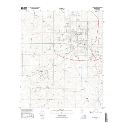
2017 Map of El Dorado West
USGS Topo · Published 2017About this map
El Dorado anchors this western Union County landscape, where the urban grid of the city meets a network of southern bayous and creeks. The western edges of the city are defined by institutional anchors such as the South Arkansas Community College and the El Dorado Downtown-Stevens Field, while the surrounding countryside preserves a dense collection of family and community burial grounds, including the Arlington Cem and Old Parkers Chapel Cem.
Find a feature on this map
99 named features on this map. Tap any name to fly to it.
Don’t see what you’re looking for? This feature index may not catch every label — zoom into the map to look around manually.
Map Details
Editions of this 2017 El Dorado West Map
This is the sole edition of this map. No revisions or reprints were ever made.
Other maps of this area

1927 · El Dorado
USGS Topo · 1:62,500

1930 · El Dorado
USGS Topo · 1:62,500

1951 · El Dorado
USGS Topo · 1:62,500

1953 · El Dorado
USGS Topo · 1:250,000

1957 · El Dorado
USGS Topo · 1:250,000

1958 · El Dorado
USGS Topo · 1:250,000

1960 · El Dorado
USGS Topo · 1:250,000

1962 · Lisbon
USGS Topo · 1:24,000

1962 · Smackover
USGS Topo · 1:24,000
1962 · Calion
USGS Topo · 1:24,000