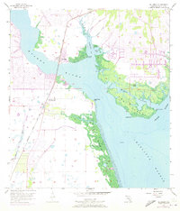
1957 Map of El Jobean
USGS Topo · Published 1973About this map
Myakka River and the Peace River converge at the northern reaches of Charlotte Harbor, defining a landscape of complex tidal estuaries and developing coastal settlements. This mid-century coastal survey captures the expansion of Port Charlotte and Charlotte Beach alongside established transit corridors like the Seaboard Coast Line railroad. The waterway geography is particularly detailed, featuring numerous named points and coves such as Cattle Dock Point, Ghost Point, and Muddy Cove within Tippecanoe Bay.
Find a feature on this map
30 named features on this map. Tap any name to fly to it.
Don’t see what you’re looking for? This feature index may not catch every label — zoom into the map to look around manually.
Map Details
Editions of this 1957 El Jobean Map
5 editions found
Other maps of this area

1944 · Myakka River
USGS Topo · 1:31,680

1956 · Murdock
USGS Topo · 1:24,000

1956 · Murdock SE
USGS Topo · 1:24,000

1956 · Punta Gorda SE
USGS Topo · 1:24,000

1956 · Englewood
USGS Topo · 1:24,000

1956 · Tampa
USGS Topo · 1:250,000

1956 · Charlotte Harbor
USGS Topo · 1:250,000

1957 · El Jobean
USGS Topo · 1:24,000

1957 · Punta Gorda SW
USGS Topo · 1:24,000

1957 · Punta Gorda
USGS Topo · 1:24,000