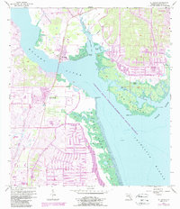
1957 Map of El Jobean
USGS Topo · Published 1987About this map
The Myakka River and Peace River converge here into the expanse of Charlotte Harbor, defining a landscape of tidal flats and intricate waterways. This survey, based on 1957 topography with 1980s updates, captures the development of El Jobean and the early footprints of Port Charlotte alongside much older features. An Old Railroad Grade cuts south through the terrain toward the water, a remnant of earlier transport networks.
Find a feature on this map
26 named features on this map. Tap any name to fly to it.
Don’t see what you’re looking for? This feature index may not catch every label — zoom into the map to look around manually.
Map Details
Editions of this 1957 El Jobean Map
5 editions found
Other maps of this area

1944 · Myakka River
USGS Topo · 1:31,680

1956 · Murdock
USGS Topo · 1:24,000

1956 · Murdock SE
USGS Topo · 1:24,000

1956 · Punta Gorda SE
USGS Topo · 1:24,000

1956 · Englewood
USGS Topo · 1:24,000

1956 · Tampa
USGS Topo · 1:250,000

1956 · Charlotte Harbor
USGS Topo · 1:250,000

1957 · El Jobean
USGS Topo · 1:24,000

1957 · Punta Gorda SW
USGS Topo · 1:24,000

1957 · Punta Gorda
USGS Topo · 1:24,000