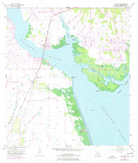
1957 Map of El Jobean
USGS Topo · Published 1977About this map
El Jobean and the surrounding shoreline of Charlotte Harbor appear here at a time of significant transition along the Florida Gulf Coast. The Seaboard Coast Line railroad cuts across the Myakka River, anchoring early 20th-century transportation patterns before the massive residential canal developments seen in neighboring Port Charlotte began to dominate the landscape. The intricate network of coastal marshes and tidal passages is defined by features like Myakka Cutoff and the sprawling Hog Island, showing the natural hydrology before extensive modern dredging.
Find a feature on this map
28 named features on this map. Tap any name to fly to it.
Don’t see what you’re looking for? This feature index may not catch every label — zoom into the map to look around manually.
Map Details
Editions of this 1957 El Jobean Map
5 editions found
Other maps of this area

1944 · Myakka River
USGS Topo · 1:31,680

1956 · Murdock
USGS Topo · 1:24,000

1956 · Murdock SE
USGS Topo · 1:24,000

1956 · Punta Gorda SE
USGS Topo · 1:24,000

1956 · Englewood
USGS Topo · 1:24,000

1956 · Tampa
USGS Topo · 1:250,000

1956 · Charlotte Harbor
USGS Topo · 1:250,000

1957 · El Jobean
USGS Topo · 1:24,000

1957 · Punta Gorda SW
USGS Topo · 1:24,000

1957 · Punta Gorda
USGS Topo · 1:24,000