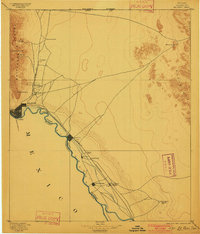
1896 Map of El Paso
USGS Topo · Published 1901About this map
The Rio Grande serves as the focal point of this late nineteenth-century borderlands survey, defining the international boundary between El Paso and Juarez. The map illustrates a landscape in transition, where established agricultural settlements like Ysleta, Socorro, and San Elizario are joined by the expanding infrastructure of the Southern Pacific Railroad and the White Oaks R.R.. The presence of Fort Bliss and its accompanying Military Reservation underscores the strategic importance of this pass through the Franklin Mountains.
Find a feature on this map
31 named features on this map. Tap any name to fly to it.
Don’t see what you’re looking for? This feature index may not catch every label — zoom into the map to look around manually.
Map Details
Editions of this 1896 El Paso Map
2 editions found
Other maps of this area

1891 · Las Cruces
USGS Topo · 1:125,000

1893 · Las Cruces
USGS Topo · 1:125,000

1894 · Fort Hancock
USGS Topo · 1:125,000

1896 · El Paso
USGS Topo · 1:125,000

1896 · Rio Grande
USGS Topo · 1:125,000

1903 · Cerro Alto
USGS Topo · 1:125,000

1908 · El Paso
USGS Topo · 1:125,000

1917 · Canutillo
USGS Topo · 1:62,500

1919 · Canutillo
USGS Topo · 1:62,500

1939 · Ysleta
USGS Topo · 1:62,500