
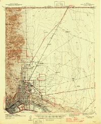
1943 Map of El Paso
USGS Topo · Published 1943About this map
The Fort Bliss Military Reservation dominates the eastern landscape of this pre-war survey, showcasing the sprawling tactical and medical infrastructure of the era. The presence of the Wm Beaumont Hospital and the Radford Sch highlights a growing urban center supported by major institutions. To the south, the international boundary along the Rio Grande reveals the unique geography of Cordova Island, a pocket of land situated between El Paso City and Juarez. Industrial activity is concentrated near the rail corridors of the Southern Pacific and Texas and Pacific, where a massive Copper Smelter and various Oil Tanks define the local economy. Educational landmarks like Loretto College and Austin High Sch serve the residential neighborhoods of Austin Terrace and Morningside, bridging the gap between the desert slopes of Mt Franklin and the river valley floor.
Find a feature on this map
62 named features on this map. Tap any name to fly to it.
Don’t see what you’re looking for? This feature index may not catch every label — zoom into the map to look around manually.
Map Details
Editions of this 1943 El Paso Map
This is the sole edition of this map. No revisions or reprints were ever made.
Other maps of this area

1896 · El Paso
USGS Topo · 1:125,000

1908 · El Paso
USGS Topo · 1:125,000

1917 · Canutillo
USGS Topo · 1:62,500

1919 · Canutillo
USGS Topo · 1:62,500

1939 · Ysleta
USGS Topo · 1:62,500

1941 · El Paso
USGS Topo · 1:31,680

1941 · Ysleta
USGS Topo · 1:62,500

1942 · Fort Bliss
USGS Topo · 1:62,500

1945 · Ysleta
USGS Topo · 1:62,500
1945 · Fort Bliss
USGS Topo · 1:62,500