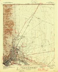
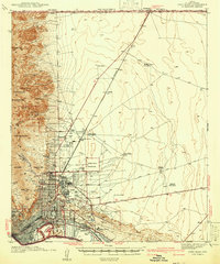
1945 Map of Fort Bliss
USGS Topo · Published 1945About this map
Fort Bliss Military Reservation dominates this 1945 landscape, illustrating a pivotal moment for the El Paso region as military infrastructure integrated with the high desert terrain. The map details the complex footprint of Biggs Field U S Military Res and the Castner Range Military Reservation, set against the backdrop of the Franklin Mountains. Evidence of early agricultural and livestock operations appears in the desert flats, with named locales like Tobin Ranch, McElroy Cow Camp, and the uniquely named Sherman Hog Ranch providing specific points for genealogical research. To the south, the developing city of El Paso reveals established neighborhoods such as Kern Place and Austin Terrace, along with educational landmarks like Loretto College. The presence of the CCC Camp and a Copper Smelter reflects the era's dual focus on public works and industrial production along the Rio Grande border.
Find a feature on this map
56 named features on this map. Tap any name to fly to it.
Don’t see what you’re looking for? This feature index may not catch every label — zoom into the map to look around manually.
Map Details
Editions of this 1945 Fort Bliss Map
This is the sole edition of this map. No revisions or reprints were ever made.
Historical Maps of El Paso Through Time
Featured Locations
- El Paso, TX
- Turf Estates Number 1 Colonia, TX
- Mission Hills, El Paso
- Planeport, El Paso
- Sunrise Acres, El Paso