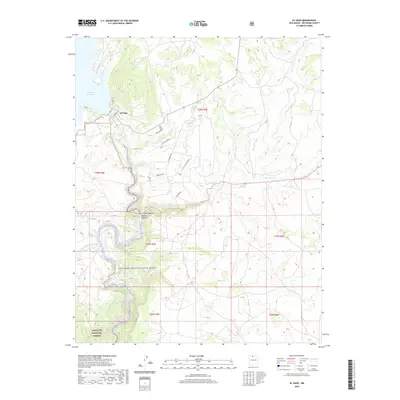
2020 Map of El Vado
USGS Topo · Published 2020About this map
El Vado Reservoir and the meandering course of the Rio Chama Wild and Scenic River dominate this high-elevation landscape in Rio Arriba County. The small settlement of El Vado is positioned near the reservoir, serving as a gateway to the steep-walled Chama Canyon and Nutrias Canyon that cut through the terrain. The topography is defined by complex drainage systems, including Cooper Arroyo and Rio Nutrias, which flow through various mountain ranges and forested lands.
Find a feature on this map
22 named features on this map. Tap any name to fly to it.
Don’t see what you’re looking for? This feature index may not catch every label — zoom into the map to look around manually.
Map Details
Editions of this 2020 El Vado Map
This is the sole edition of this map. No revisions or reprints were ever made.
Other maps of this area
1909 · Gallina
USGS Topo · 1:125,000
1953 · Alire
USGS Topo · 1:24,000
1953 · Navajo Peak
USGS Topo · 1:24,000

1954 · Aztec
USGS Topo · 1:250,000
1955 · Llaves
USGS Topo · 1:62,500
1955 · Tierra Amarilla
USGS Topo · 1:62,500
1955 · Boulder Lake
USGS Topo · 1:62,500
1958 · Aztec
USGS Topo · 1:250,000
1962 · Aztec
USGS Topo · 1:250,000
1965 · Aztec
USGS Topo · 1:250,000