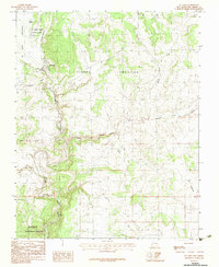
1983 Map of El Vado
USGS Topo · Published 1983About this map
Rio Chama carves a deep path through the high plateau of Rio Arriba County, anchoring a landscape where water and historical land grants define the geography. The presence of the Tierra Amarilla Grant boundary indicates the enduring influence of Spanish and Mexican land legacies on this northern New Mexico terrain. Centered around El Vado Lake and the El Vado Lake State Park, the map illustrates a transition from the structured recreational areas of the reservoir to the wilder reaches of the Santa Fe National Forest. The small settlement of El Vado sits near the dam, while the surrounding canyons, such as Chama Canyon and Nutrias Canyon, demonstrate the erosive power of the drainage systems feeding into the river. This 1980s-era survey documents the intersection of public lands, private grant histories, and the critical water management infrastructure that sustains the region.
Find a feature on this map
18 named features on this map. Tap any name to fly to it.
Don’t see what you’re looking for? This feature index may not catch every label — zoom into the map to look around manually.
Map Details
Editions of this 1983 El Vado Map
This is the sole edition of this map. No revisions or reprints were ever made.
Other maps of this area

1909 · Gallina
USGS Topo · 1:125,000

1953 · Alire
USGS Topo · 1:24,000

1953 · Navajo Peak
USGS Topo · 1:24,000

1954 · Aztec
USGS Topo · 1:250,000

1955 · Llaves
USGS Topo · 1:62,500

1955 · Tierra Amarilla
USGS Topo · 1:62,500

1955 · Boulder Lake
USGS Topo · 1:62,500

1958 · Aztec
USGS Topo · 1:250,000

1962 · Aztec
USGS Topo · 1:250,000

1965 · Aztec
USGS Topo · 1:250,000