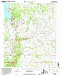
2002 Map of El Vado
USGS Topo · Published 2003About this map
El Vado Reservoir dominates this landscape in northern New Mexico, where the Rio Chama flows through deep sandstone cuts including the dramatic Chama Canyon. The map details the small settlement of El Vado, a focal point for the region's infrastructure featuring a Gaging Station and spillway. This area serves as a junction between the massive historic land holdings of the Tierra Amarilla Grant and the protected wilderness of the Santa Fe National Forest. Evidence of local industry is scattered across the high mesas, including a isolated Oil Well, a Drill Hole, and a Gas Well, illustrating the extractive history that accompanies the recreational draw of El Vado Lake State Park. Along the banks of Puerto Chiquito, a lone Cem remains as a quiet marker of early habitation in this arid, high-altitude terrain.
Find a feature on this map
27 named features on this map. Tap any name to fly to it.
Don’t see what you’re looking for? This feature index may not catch every label — zoom into the map to look around manually.
Map Details
Editions of this 2002 El Vado Map
This is the sole edition of this map. No revisions or reprints were ever made.
Other maps of this area

1909 · Gallina
USGS Topo · 1:125,000

1953 · Alire
USGS Topo · 1:24,000

1953 · Navajo Peak
USGS Topo · 1:24,000

1954 · Aztec
USGS Topo · 1:250,000

1955 · Llaves
USGS Topo · 1:62,500

1955 · Tierra Amarilla
USGS Topo · 1:62,500

1955 · Boulder Lake
USGS Topo · 1:62,500

1958 · Aztec
USGS Topo · 1:250,000

1962 · Aztec
USGS Topo · 1:250,000

1965 · Aztec
USGS Topo · 1:250,000