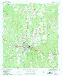
1968 Map of Elba
USGS Topo · Published 1984About this map
The Pea River and Whitewater Creek converge at the town of Elba, a community defined by its proximity to these winding waterways and the Seaboard rail line. This survey, photorevised in the early 1980s, captures the town's expansion with additions like the Carl Folsom Airport and the Elba Country Club north of the main settlement. The landscape is dotted with rural landmarks essential for genealogical research, including the Evergreen Cemetery, Hillcrest Cem, and several country churches such as Wise Mill Ch and Rocky Head Ch.
Find a feature on this map
34 named features on this map. Tap any name to fly to it.
Don’t see what you’re looking for? This feature index may not catch every label — zoom into the map to look around manually.
Map Details
Editions of this 1968 Elba Map
2 editions found
Other maps of this area

1942 · Enterprise
USGS Topo · 1:125,000

1948 · Brundidge
USGS Topo · 1:62,500

1950 · Enterprise
USGS Topo · 1:62,500

1950 · Brundidge
USGS Topo · 1:62,500

1953 · Andalusia
USGS Topo · 1:250,000

1953 · Dothan
USGS Topo · 1:250,000

1954 · Dothan
USGS Topo · 1:250,000

1955 · Dothan
USGS Topo · 1:250,000

1957 · Andalusia
USGS Topo · 1:250,000

1960 · Victoria
USGS Topo · 1:24,000