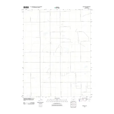
2010 Map of Elba SW
USGS Topo · Published 2010About this map
Washington County’s agricultural landscape is defined by a rigorous section-line road network in this 2010 survey of the Elba SW quadrangle. The terrain is organized by a systematic grid of routes, including County Road BB, County Road DD, and County Road EE, which facilitate transit across the open High Plains. While the map is sparse in named settlements, the intricate hydrography of ephemeral stream beds and seasonal drainages reveals the natural drainage patterns that have dictated land use and homestead placement in this corner of Colorado. The presence of specialized designations like County Rd-19 5/10 and County Road FF 5/10 suggests a high degree of local precision in navigating the rural property divisions that sustain the region's ranching and farming economy.
Find a feature on this map
16 named features on this map. Tap any name to fly to it.
Don’t see what you’re looking for? This feature index may not catch every label — zoom into the map to look around manually.
Map Details
Editions of this 2010 Elba SW Map
This is the sole edition of this map. No revisions or reprints were ever made.
Other maps of this area

1954 · Limon
USGS Topo · 1:250,000

1957 · Limon
USGS Topo · 1:250,000

1958 · Limon
USGS Topo · 1:250,000

1973 · Antelope Creek East
USGS Topo · 1:24,000

1973 · Lindon NE
USGS Topo · 1:24,000

1973 · Antelope Creek SE
USGS Topo · 1:24,000
1974 · Elba
USGS Topo · 1:24,000
1977 · Elba SW
USGS Topo · 1:24,000

1977 · Arickaree
USGS Topo · 1:24,000
1977 · Elba NE
USGS Topo · 1:24,000