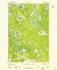
1950 Map of Elcho
USGS Topo · Published 1955About this map
Pelican Lake serves as a northern anchor for this 1950s landscape, where the waters of Guths Bay and Antigo I meet a dense network of timberlands and seasonal retreats. The Chicago and North Western railway provides the primary structural axis, connecting the village of Elcho and the high-elevation settlement of Summit Lake with regional markets. This era shows a transition from a purely extractive economy to one defined by early tourism and managed forestry, evidenced by the Summit Lake Ranger Station and the Pence Lake Lookout Tower overlooking the massive Wolf River and Hunting River basins. Community life is centered around small rural institutions like St Johns Ch and schools including Little Chicago Sch and Forest Sch, while the presence of several old railroad grades hints at the logging spurs that once reached deeper into the surrounding swamps.
Find a feature on this map
109 named features on this map. Tap any name to fly to it.
Don’t see what you’re looking for? This feature index may not catch every label — zoom into the map to look around manually.
Map Details
Editions of this 1950 Elcho Map
3 editions found

Other maps of this area

1899 · Wausau
USGS Topo · 1:125,000

1902 · Wausau
USGS Topo · 1:125,000

1939 · Crandon
USGS Topo · 1:48,000

1940 · Parrish
USGS Topo · 1:48,000

1940 · Monico
USGS Topo · 1:48,000

1940 · Rhinelander
USGS Topo · 1:48,000

1941 · Crandon
USGS Topo · 1:48,000

1942 · Elcho
USGS Topo · 1:48,000

1942 · Pearson
USGS Topo · 1:48,000

1947 · Crandon
USGS Topo · 1:48,000