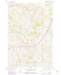
1960 Map of Eldering Ranch
USGS Topo · Published 1980About this map
Eldering Ranch sits at the heart of this Montana landscape, where the drainage systems of Treasure County converge toward the river valley. The northern edge of the sheet is defined by the Yellowstone River and the corridor of the Northern Pacific railroad, reflecting the primary transportation and irrigation spine of the region. Moving south, the terrain becomes a complex network of coulees and seasonal creeks, including Jacobs Coulee and Buckingham Coulee.
Find a feature on this map
22 named features on this map. Tap any name to fly to it.
Don’t see what you’re looking for? This feature index may not catch every label — zoom into the map to look around manually.
Map Details
Editions of this 1960 Eldering Ranch Map
3 editions found
Other maps of this area

1954 · Forsyth
USGS Topo · 1:250,000

1957 · Forsyth
USGS Topo · 1:250,000

1958 · Forsyth
USGS Topo · 1:250,000

1960 · Bighorn
USGS Topo · 1:24,000

1960 · Hysham
USGS Topo · 1:24,000

1960 · Myers
USGS Topo · 1:24,000

1960 · Rancher Cemetery
USGS Topo · 1:24,000

1960 · Marsh Coulee
USGS Topo · 1:24,000

1960 · Eldering Ranch
USGS Topo · 1:24,000

1960 · Hope Ranch
USGS Topo · 1:24,000