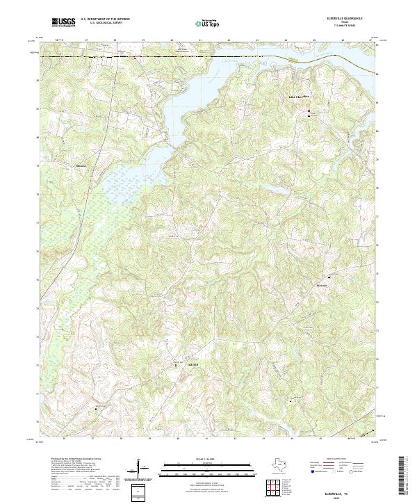
2022 Map of Elderville
USGS Topo · Published 2022About this map
The boundary between Gregg Co and Rusk Co cuts across this East Texas landscape, dominated by the winding fingers of Lake Cherokee. This modern survey reveals a region shaped by both its aviation infrastructure and its rural heritage. To the north, the East Texas Regional Airport occupies a significant footprint, while the surrounding terrain is a network of small creeks and branches including Bacon Cr, Tiawichi Cr, and Lee Cr that feed into the central bayou system. Local history is anchored by numerous community burial grounds such as Elderville Cem, Chalk Hill Cem, and Stewart Cem, which mark the small settlements of Monroe, Stewart, and Oak Hill. The presence of Beaver Marsh and dense creek networks illustrates the complex hydrology of the Sabine River basin tributaries that define this area of the Piney Woods.
Find a feature on this map
81 named features on this map. Tap any name to fly to it.
Don’t see what you’re looking for? This feature index may not catch every label — zoom into the map to look around manually.
Map Details
Editions of this 2022 Elderville Map
This is the sole edition of this map. No revisions or reprints were ever made.
Other maps of this area

1935 · Henderson
USGS Topo · 1:48,000

1936 · Kilgore
USGS Topo · 1:48,000

1939 · Henderson
USGS Topo · 1:62,500

1940 · Kilgore
USGS Topo · 1:62,500

1956 · Tyler
USGS Topo · 1:250,000

1958 · Tatum
USGS Topo · 1:62,500

1960 · Minden
USGS Topo · 1:62,500

1971 · Kilgore NE
USGS Topo · 1:24,000
1971 · Kilgore SE
USGS Topo · 1:24,000

1973 · Henderson
USGS Topo · 1:24,000