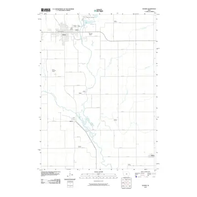
2010 Map of Eldora
USGS Topo · Published 2010About this map
Eldora serves as the focal point of this Hardin County landscape, situated where the Iowa River begins its winding course southward toward Gifford and Whitten. The river's path is characterized by a wide floodplain, particularly evident near the South Fork Iowa River confluence. North of the city, the Upper Pine Lake Dam creates Pine Lake, a distinctive water body that stands in contrast to the surrounding agricultural grid. This survey provides a meticulous record of local interment sites, tracing family and community history through a high density of rural burial grounds.
Find a feature on this map
55 named features on this map. Tap any name to fly to it.
Don’t see what you’re looking for? This feature index may not catch every label — zoom into the map to look around manually.
Map Details
Editions of this 2010 Eldora Map
This is the sole edition of this map. No revisions or reprints were ever made.
Other maps of this area

1954 · Waterloo
USGS Topo · 1:250,000

1955 · Waterloo
USGS Topo · 1:250,000

1960 · Marshalltown
USGS Topo · 1:62,500

1960 · Conrad West
USGS Topo · 1:24,000

1975 · State Center NW
USGS Topo · 1:24,000

1975 · Union
USGS Topo · 1:24,000

1979 · Steamboat Rock
USGS Topo · 1:24,000

1979 · New Providence
USGS Topo · 1:24,000

1979 · Eldora
USGS Topo · 1:24,000
1979 · Owasa
USGS Topo · 1:24,000