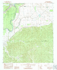
1988 Map of Eldorado
USGS Topo · Published 1988About this map
The Yazoo River winds through the heart of this landscape, marking the transition from the low-lying wetlands of the Delta National Forest to the dissected uplands of the Yazoo and Warren county border. Small settlements like Eldorado and Russellville sit at the margins of these hills, while the community of Ballground is situated further west near Ballground Creek. The map documents a rural Mississippi economy shaped by natural resources and former transport lines, evidenced by a Gravel Pit and the path of an Old RR Grade cutting through the terrain. Extensive hydrological features such as The Basin, Collins Creek, and Corn House Creek define the drainage patterns of the area, illustrating the complex relationship between the floodplains and the surrounding elevations during the late twentieth century.
Find a feature on this map
16 named features on this map. Tap any name to fly to it.
Don’t see what you’re looking for? This feature index may not catch every label — zoom into the map to look around manually.
Map Details
Editions of this 1988 Eldorado Map
This is the sole edition of this map. No revisions or reprints were ever made.
Other maps of this area

1918 · Vicksburg
USGS Topo · 1:62,500

1938 · Edwards
USGS Topo · 1:62,500

1939 · Onward
USGS Topo · 1:62,500

1940 · Mechanicsburg
USGS Topo · 1:62,500

1941 · Vicksburg
USGS Topo · 1:62,500

1955 · Jackson
USGS Topo · 1:250,000

1961 · Jackson
USGS Topo · 1:250,000

1962 · Jackson
USGS Topo · 1:250,000

1962 · Redwood
USGS Topo · 1:24,000

1963 · Mechanicsburg
USGS Topo · 1:62,500