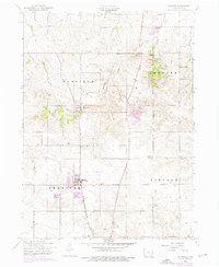
1953 Map of Eldridge
USGS Topo · Published 1976About this map
Eldridge and Long Grove anchor this mid-century survey of rural Scott County, capturing a landscape transitioning through suburban development while maintaining its deep agricultural roots. The eastern sections are dominated by Scott County Park and the burgeoning residential layout of Park View, showing a 1970s expansion over the earlier rural township lines of Butler and Winfield. The transportation network is defined by the Chicago Milwaukee St Paul and Pacific railroad corridor, which historically supported the shipment of local grain and livestock from these prairie communities.
Find a feature on this map
26 named features on this map. Tap any name to fly to it.
Don’t see what you’re looking for? This feature index may not catch every label — zoom into the map to look around manually.
Map Details
Editions of this 1953 Eldridge Map
3 editions found
Other maps of this area

1891 · DeWitt
USGS Topo · 1:62,500

1891 · Davenport
USGS Topo · 1:62,500

1892 · Goose Lake
USGS Topo · 1:62,500

1892 · Leclaire
USGS Topo · 1:62,500

1893 · Leclaire
USGS Topo · 1:62,500

1894 · Goose Lake
USGS Topo · 1:62,500

1894 · Davenport
USGS Topo · 1:62,500

1899 · Clinton
USGS Topo · 1:125,000

1901 · Rock Island
USGS Topo · 1:125,000

1910 · Rock Island
USGS Topo · 1:125,000