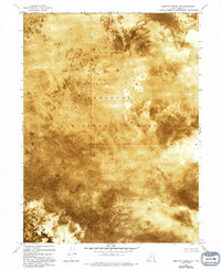
1972 Map of Elephant Knoll NE
USGS Topo · Published 1994About this map
The Wendover Air Force Range dominates this orthophotomap of Tooele County, representing a landscape defined by military utility and geological extremes. The vast expanse of Alkali or Mud flats illustrates the remote, arid character of the Great Salt Lake Desert, where the lack of vegetation or natural drainage creates a nearly featureless surface. This 1970s survey captures the area during a period of ongoing military testing and training, providing a precise record of a territory where very few permanent markers exist beyond established boundary lines and isolated benchmarks. The absence of roads or cultural developments outside of military designations highlights the isolation of this specialized landscape, which remains one of the most physically challenging environments in the American West.
Find a feature on this map
9 named features on this map. Tap any name to fly to it.
Don’t see what you’re looking for? This feature index may not catch every label — zoom into the map to look around manually.
Map Details
Editions of this 1972 Elephant Knoll NE Map
2 editions found
Other maps of this area

1953 · Tooele
USGS Topo · 1:250,000

1955 · Tooele
USGS Topo · 1:250,000

1972 · Elephant Knoll
USGS Topo · 1:24,000
1972 · Elephant Knoll NW
USGS Topo · 1:24,000
1972 · Elephant Knoll NE
USGS Topo · 1:24,000

1972 · Elephant Knoll SE
USGS Topo · 1:24,000

1973 · Arinosa SW
USGS Topo · 1:24,000
1973 · Salduro SW
USGS Topo · 1:24,000

1973 · Salduro SE
USGS Topo · 1:24,000

1973 · Gold Hill 1 SW
USGS Topo · 1:24,000