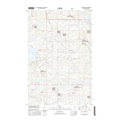
2016 Map of Elephant Lake
USGS Topo · Published 2016About this map
Elephant Lake and Silver Lake anchor this 2016 study of the northern wilderness within the Superior National Forest. This section of Saint Louis County is defined by a dense network of waterways, where the Pelican River and Vermilion River navigate a landscape of wetlands and low-lying basins. The map illustrates a contemporary balance between recreational access and preservation, evidenced by the winding path of the Arrowhead Snowmobile Trail and numerous forest routes like Forest Rd 203 and the Marion Lake Spur. While residential development is sparse, concentrated primarily along N Elephant Lake Rd, the cartography focuses on the complex drainage of smaller tributaries such as Elephant Cr, Bug Cr, and Clear Cr. This modern survey provides an exact look at the topography and water levels in the years following the turn of the twenty-first century.
Find a feature on this map
24 named features on this map. Tap any name to fly to it.
Don’t see what you’re looking for? This feature index may not catch every label — zoom into the map to look around manually.
Map Details
Editions of this 2016 Elephant Lake Map
This is the sole edition of this map. No revisions or reprints were ever made.
Other maps of this area

1954 · International Falls
USGS Topo · 1:250,000

1957 · International Falls
USGS Topo · 1:250,000

1958 · International Falls
USGS Topo · 1:250,000

1967 · Kabustasa Lake
USGS Topo · 1:24,000

1967 · Marion Lake
USGS Topo · 1:24,000

1967 · Elephant Lake
USGS Topo · 1:24,000
1967 · Buyck
USGS Topo · 1:24,000

1967 · Johnson Lake
USGS Topo · 1:24,000
1968 · Myrtle Lake
USGS Topo · 1:24,000

1968 · Ash River SE
USGS Topo · 1:24,000