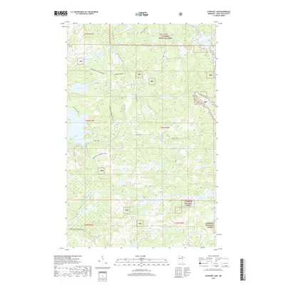
2019 Map of Elephant Lake
USGS Topo · Published 2019About this map
Superior National Forest encompasses this stretch of Saint Louis County, where a dense network of water bodies and recreational corridors defines the landscape. Major features include the expansive Elephant Lake and its smaller neighbor Silver Lake, alongside the remote waters of Bug Lake. The drainage patterns are clearly marked by the Pelican River and Vermilion River, which are fed by several tributaries such as Elephant Cr, Bug Cr, and Clear Cr. This 2019 survey reflects the area's modern emphasis on forest management and outdoor recreation, detailing a system of timber access roads and designated trails. Notable transit corridors like the Arrowhead Snowmobile Trail and the Bug Creek Trail cut through the timbered sections, while Forest Rd 203 and Marion Lake Spur provide deep interior access for researchers or explorers tracking land use in the North Woods.
Find a feature on this map
25 named features on this map. Tap any name to fly to it.
Don’t see what you’re looking for? This feature index may not catch every label — zoom into the map to look around manually.
Map Details
Editions of this 2019 Elephant Lake Map
This is the sole edition of this map. No revisions or reprints were ever made.
Other maps of this area

1954 · International Falls
USGS Topo · 1:250,000

1957 · International Falls
USGS Topo · 1:250,000

1958 · International Falls
USGS Topo · 1:250,000

1967 · Kabustasa Lake
USGS Topo · 1:24,000

1967 · Marion Lake
USGS Topo · 1:24,000

1967 · Elephant Lake
USGS Topo · 1:24,000
1967 · Buyck
USGS Topo · 1:24,000

1967 · Johnson Lake
USGS Topo · 1:24,000
1968 · Myrtle Lake
USGS Topo · 1:24,000

1968 · Ash River SE
USGS Topo · 1:24,000