Loading...
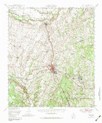
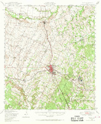
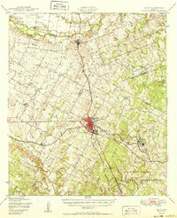
Loading map...1948 Map of Elgin
USGS Topo · Published 1984About this map
Elgin serves as the central hub of this Central Texas landscape, situated at the crossroads of the Missouri Kansas and Texas RR and the Southern Pacific railroads. The map documents a rural society deeply rooted in small-town commerce and agriculture, evidenced by the numerous schools and churches scattered across the blackland prairies, such as Red Town Sch and Union Lee Ch. To the south, the Camp Swift Military Reservation dominates the terrain, marking a significant wartime and post-war presence in the region.
Find a feature on this map
44 named features on this map. Tap any name to fly to it.
Don’t see what you’re looking for? This feature index may not catch every label — zoom into the map to look around manually.
Map Details
Date Portrayed1948
Date Published1984
PublisherU.S. Geological Survey
Map TypeTopographic
Scale1:62,500
Physical Dimensions18 x 21.8 inches
Editions of this 1948 Elgin Map
2 editions found
Historical Maps of Manor Through Time
Featured Locations
Source Details
SourceU.S. Geological Survey
CopyrightPublic Domain