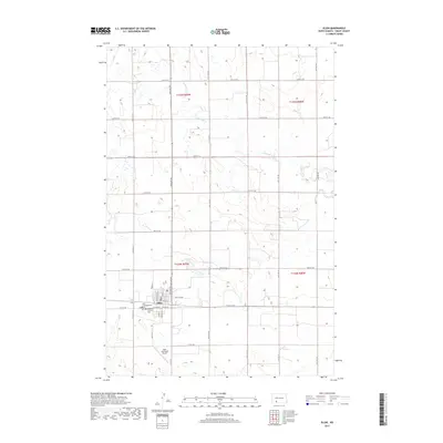
2017 Map of Elgin
USGS Topo · Published 2017About this map
Elgin serves as the primary hub of this Grant County landscape, situated where the local grid of agricultural roads meets the meandering path of Antelope Cr. The settlement is clearly defined by its residential blocks and central services, including the Elgin Municipal Airport to the south. Reflecting the town's community history, two religious sites are located on the western edge of the town site: the Hope Congregational Cem and the American Lutheran Cem. The surrounding terrain is dominated by the section lines of the Public Land Survey System, with the map recording the intersections of Townships 134N and 135N. This survey illustrates the persistent importance of regional corridors like Elgin Rd and Golf Club Rd in connecting the isolated farmsteads of the North Dakota plains.
Find a feature on this map
25 named features on this map. Tap any name to fly to it.
Don’t see what you’re looking for? This feature index may not catch every label — zoom into the map to look around manually.
Map Details
Editions of this 2017 Elgin Map
This is the sole edition of this map. No revisions or reprints were ever made.
Other maps of this area

1938 · Heart Butte
USGS Topo · 1:48,000

1944 · Heart Butte
USGS Topo · 1:62,500

1954 · Bismarck
USGS Topo · 1:250,000

1958 · Bismarck
USGS Topo · 1:250,000

1972 · Leith
USGS Topo · 1:24,000

1972 · New Leipzig South
USGS Topo · 1:24,000

1972 · Sheep Creek Dam
USGS Topo · 1:24,000
1980 · Lake Tschida East
USGS Topo · 1:24,000

1980 · Heil
USGS Topo · 1:24,000

1980 · Crown Butte Creek SW
USGS Topo · 1:24,000