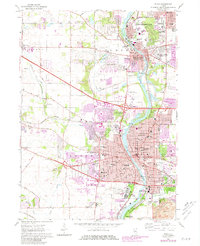
1962 Map of Elgin
USGS Topo · Published 1981About this map
The Fox River valley serves as the primary corridor for growth and industry in this northern Illinois survey, which highlights the expanding urban footprints of Elgin and the surrounding villages during the mid-20th century. Suburban development is shown pushing westward from the river into the townships of Rutland and Dundee, while the Northwest Tollway establishes a modern transit spine across the landscape. The map provides significant detail for genealogists and local historians, documenting dozens of neighborhood institutions including the Elgin Academy and the sprawling Elgin State Hospital complex. In the north, the twin settlements of West Dundee and East Dundee maintain their distinct identities along the riverbanks, while smaller communities like Gilberts and Almora remain centered on established rail lines such as the Chicago Milwaukee St Paul and Pacific.
Find a feature on this map
74 named features on this map. Tap any name to fly to it.
Don’t see what you’re looking for? This feature index may not catch every label — zoom into the map to look around manually.
Map Details
Editions of this 1962 Elgin Map
4 editions found
Other maps of this area

1908 · Wheaton
USGS Topo · 1:62,500

1923 · Barrington
USGS Topo · 1:62,500

1925 · Elgin
USGS Topo · 1:62,500

1932 · Geneva
USGS Topo · 1:62,500

1935 · Barrington
USGS Topo · 1:62,500

1940 · Elgin
USGS Topo · 1:62,500

1948 · Wheaton
USGS Topo · 1:62,500

1948 · Geneva
USGS Topo · 1:62,500

1949 · Geneva
USGS Topo · 1:24,000

1953 · West Chicago
USGS Topo · 1:24,000