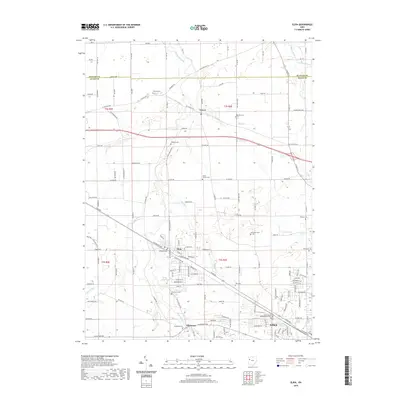
2019 Map of Elida
USGS Topo · Published 2019About this map
The Ottawa River meanders through the heart of this landscape, connecting the village of Elida with the neighboring settlement of Allentown. This 2019 survey documents a region transitioning from traditional farmland to suburban expansion, most notably visible where the northwest edge of Lima meets the campus of the University of Northwestern Ohio. Local history and genealogy are well-represented by a high density of rural burial grounds, including the Ash Grove Cem and the Dutch Hollow Cem.
Find a feature on this map
125 named features on this map. Tap any name to fly to it.
Don’t see what you’re looking for? This feature index may not catch every label — zoom into the map to look around manually.
Map Details
Editions of this 2019 Elida Map
This is the sole edition of this map. No revisions or reprints were ever made.
Other maps of this area

1906 · Lima
USGS Topo · 1:62,500

1906 · Columbus Grove
USGS Topo · 1:62,500

1908 · Columbus Grove
USGS Topo · 1:62,500

1911 · Spencerville
USGS Topo · 1:62,500

1911 · Delphos
USGS Topo · 1:62,500

1944 · Delphos
USGS Topo · 1:62,500

1944 · Spencerville
USGS Topo · 1:62,500

1953 · Muncie
USGS Topo · 1:250,000

1956 · Muncie
USGS Topo · 1:250,000
1960 · Columbus Grove
USGS Topo · 1:24,000