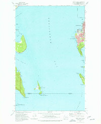
1977 Map of Eliza Island
USGS Topo · Published 1977About this map
Bellingham Bay and the coastal landscape of southern Bellingham dominate this 1970s coastal survey. The map details a maritime environment shaped by natural landforms and early infrastructure, featuring the Burlington Northern railroad corridor hugging the shoreline through South Bellingham. Residents of the era are reflected in the presence of Fairhaven Middle Sch and local thoroughfares like Bayside Road and Viewcrest Rd.
Find a feature on this map
37 named features on this map. Tap any name to fly to it.
Don’t see what you’re looking for? This feature index may not catch every label — zoom into the map to look around manually.
Map Details
Editions of this 1977 Eliza Island Map
2 editions found
Other maps of this area

1906 · Sumas
USGS Topo · 1:62,500

1907 · Blaine
USGS Topo · 1:62,500

1908 · Sumas
USGS Topo · 1:62,500

1918 · Samish Lake
USGS Topo · 1:62,500

1943 · Anacortes
USGS Topo · 1:62,500

1951 · Anacortes
USGS Topo · 1:62,500

1952 · Ferndale
USGS Topo · 1:24,000

1952 · Lummi Bay
USGS Topo · 1:24,000

1952 · Blaine
USGS Topo · 1:62,500

1954 · Bow
USGS Topo · 1:24,000