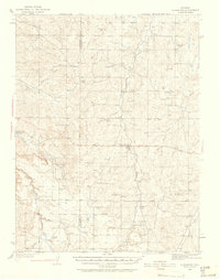
1939 Map of Elizabeth
USGS Topo · Published 1958About this map
The Site of Gold Discovery by Russell anchors the historical significance of this landscape, marking a pivotal moment in the region's mining heritage. Surveyed in the 1930s, the terrain is defined by a dense network of gulches and creeks, including Running Creek and Cherry Creek, which dictated the placement of early ranching and agricultural operations. The map reveals a robust rural infrastructure of the era, with numerous small school districts such as High Point Sch, Flintwood Sch, and Locust Grove Sch serving the scattered population around the town of Elizabeth. Large landholdings like the Edelweiss Ranch and Pine Bar Ranch reflect the dominant ranching economy, while the presence of a CCC Camp at the edge of the county line points to New Deal-era conservation work in the high plains. The boundary between Douglas and Elbert counties bisects this territory, where isolated landmarks like Hilltop and the Miller Cem provide valuable touchstones for genealogical research.
Find a feature on this map
43 named features on this map. Tap any name to fly to it.
Don’t see what you’re looking for? This feature index may not catch every label — zoom into the map to look around manually.
Map Details
Editions of this 1939 Elizabeth Map
4 editions found
Other maps of this area

1890 · East Denver
USGS Topo · 1:125,000

1894 · Castle Rock
USGS Topo · 1:125,000

1913 · Castle Rock
USGS Topo · 1:125,000

1935 · East Denver Nos. 3 and 4
USGS Topo · 1:48,000

1939 · Elizabeth
USGS Topo · 1:62,500

1940 · Piney Creek
USGS Topo · 1:24,000

1940 · Elbert
USGS Topo · 1:62,500

1940 · Castle Rock
USGS Topo · 1:62,500

1942 · Parker
USGS Topo · 1:31,680

1942 · Piney Creek
USGS Topo · 1:31,680