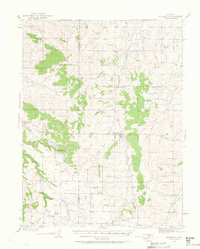
1939 Map of Elizabeth
USGS Topo · Published 1963About this map
The Site of Gold Discovery by Russell marks a pivotal point in this landscape where the high plains meet the headwaters of the South Platte drainage. Surveyed in the late 1930s, the terrain is defined by a dense network of gulches and creeks, including Cherry Creek, Running Creek, and Kiowa Creek. The settlement of Elizabeth serves as the local hub, supported by a constellation of rural community centers and one-room schoolhouses such as Gold Dale Sch, Osborn Sch, and Locust Grove Sch 2. The map also records the location of a CCC Camp and several named cattle operations like the Lone Star Ranch and Pine Bar Ranch. This era shows a transition from early pioneer mining roots to a robust ranching economy, with the boundary between Douglas and Elbert counties bisecting the drainage of Moonshine Gulch and Bayou Gulch.
Find a feature on this map
42 named features on this map. Tap any name to fly to it.
Don’t see what you’re looking for? This feature index may not catch every label — zoom into the map to look around manually.
Map Details
Editions of this 1939 Elizabeth Map
4 editions found
Other maps of this area

1890 · East Denver
USGS Topo · 1:125,000

1894 · Castle Rock
USGS Topo · 1:125,000

1913 · Castle Rock
USGS Topo · 1:125,000

1935 · East Denver Nos. 3 and 4
USGS Topo · 1:48,000

1939 · Elizabeth
USGS Topo · 1:62,500

1940 · Piney Creek
USGS Topo · 1:24,000

1940 · Elbert
USGS Topo · 1:62,500

1940 · Castle Rock
USGS Topo · 1:62,500

1942 · Parker
USGS Topo · 1:31,680

1942 · Piney Creek
USGS Topo · 1:31,680