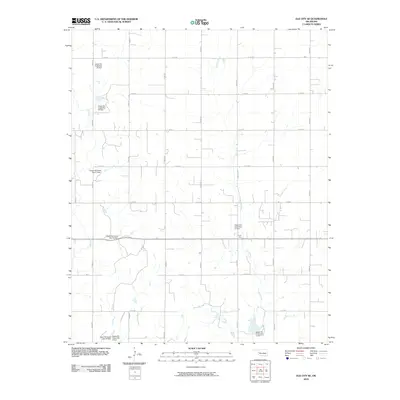
2010 Map of Elk City SE
USGS Topo · Published 2010About this map
Water management and flood control dominate this western Oklahoma landscape, where the upper reaches of the North Canadian watershed are regulated by a series of numbered dams. The hydrology of Elk Creek and its tributaries, including Trail Creek and George Creek, is defined by these engineered structures, such as Upper Elk Creek Site 15 Dam and Upper Elk Creek Site 12 Dam. The area is organized by a precise section-line road grid, including N 2050 RD and E 1180 RD, which service the rural farmsteads and agricultural plots of Beckham County. The presence of the Forty One label suggests a specific local land division or historic reference point within this systematic Oklahoma land survey. This map offers a clear view of the rural infrastructure and watershed management practices that sustain the plains economy in the early 21st century.
Find a feature on this map
27 named features on this map. Tap any name to fly to it.
Don’t see what you’re looking for? This feature index may not catch every label — zoom into the map to look around manually.
Map Details
Editions of this 2010 Elk City SE Map
This is the sole edition of this map. No revisions or reprints were ever made.
Other maps of this area

1955 · Clinton
USGS Topo · 1:250,000

1957 · Clinton
USGS Topo · 1:250,000

1957 · Dill City
USGS Topo · 1:62,500

1961 · Hobart
USGS Topo · 1:62,500

1961 · Retrop
USGS Topo · 1:62,500

1961 · Elk City
USGS Topo · 1:62,500

1976 · Dill City NE
USGS Topo · 1:24,000
1983 · Foss
USGS Topo · 1:24,000

1983 · Dill City
USGS Topo · 1:24,000

1984 · Sentinel
USGS Topo · 1:24,000