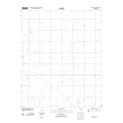
2012 Map of Elk City SE
USGS Topo · Published 2012About this map
Elk Cr and Trail Cr define the drainage of this western Oklahoma landscape in Beckham County. The area is organized by a precise grid of county roads, including E1140 Rd and N2050 Rd, which facilitate transport across the rural terrain southeast of Elk City. Small agricultural ponds and minor tributaries like George Cr are scattered throughout the quadrangle, reflecting the importance of water management in this prairie environment. The 2012 survey illustrates the modern rural layout, where longstanding Section Line roads serve as the primary network connecting scattered homesteads and ranches. This cartography provides a clear view of how the land has been partitioned for agriculture, with the perennial and intermittent streams of the Washita River watershed carving subtle valleys through the high plains.
Find a feature on this map
18 named features on this map. Tap any name to fly to it.
Don’t see what you’re looking for? This feature index may not catch every label — zoom into the map to look around manually.
Map Details
Editions of this 2012 Elk City SE Map
This is the sole edition of this map. No revisions or reprints were ever made.
Other maps of this area

1955 · Clinton
USGS Topo · 1:250,000

1957 · Clinton
USGS Topo · 1:250,000

1957 · Dill City
USGS Topo · 1:62,500

1961 · Hobart
USGS Topo · 1:62,500

1961 · Retrop
USGS Topo · 1:62,500

1961 · Elk City
USGS Topo · 1:62,500

1976 · Dill City NE
USGS Topo · 1:24,000
1983 · Foss
USGS Topo · 1:24,000

1983 · Dill City
USGS Topo · 1:24,000

1984 · Sentinel
USGS Topo · 1:24,000