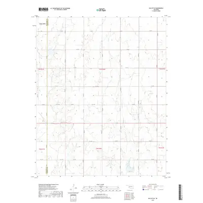
2018 Map of Elk City SE
USGS Topo · Published 2018About this map
The agricultural boundary between Beckham Co and Washita Co defines the layout of this West Oklahoma landscape. While the southern extent of Elk City appears in the northwest corner, the map primarily details the rural section-line road network that facilitates transit across the plains. Waterways such as Trail Cr and its associated Trail Creek Valley cut across the gridded landscape, joined by George Cr and Elk Cr. These natural drainage patterns contrast with the rigid Public Land Survey System geometry of T10N and T9N. The map provides a clear record of modern rural infrastructure, including labeled routes like NS 120 Rd and EW 118 Rd, which serve the homesteads and farms of this prairie region.
Find a feature on this map
41 named features on this map. Tap any name to fly to it.
Don’t see what you’re looking for? This feature index may not catch every label — zoom into the map to look around manually.
Map Details
Editions of this 2018 Elk City SE Map
This is the sole edition of this map. No revisions or reprints were ever made.
Other maps of this area

1955 · Clinton
USGS Topo · 1:250,000

1957 · Clinton
USGS Topo · 1:250,000

1957 · Dill City
USGS Topo · 1:62,500

1961 · Hobart
USGS Topo · 1:62,500

1961 · Retrop
USGS Topo · 1:62,500

1961 · Elk City
USGS Topo · 1:62,500

1976 · Dill City NE
USGS Topo · 1:24,000
1983 · Foss
USGS Topo · 1:24,000

1983 · Dill City
USGS Topo · 1:24,000

1984 · Sentinel
USGS Topo · 1:24,000