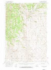
1957 Map of Elk Mountain
USGS Topo · Published 1959About this map
The Wallowa National Forest dominates this mid-century topographic landscape in northeastern Oregon, characterized by a complex network of canyons and gulches. The terrain is defined by dramatic elevation changes from Starvation Ridge and the heights of Elk Mountain down to the deep drainages of Joseph Creek and Beaver Creek. Human activity is marked by isolated landmarks like the Chico Guard Sta and the Lewis Sch, suggesting a sparse, ranching-oriented settlement pattern centered on family-held lands such as Hinton Ranch.
Find a feature on this map
67 named features on this map. Tap any name to fly to it.
Don’t see what you’re looking for? This feature index may not catch every label — zoom into the map to look around manually.
Map Details
Editions of this 1957 Elk Mountain Map
3 editions found
Other maps of this area

1954 · Imnaha
USGS Topo · 1:62,500

1954 · Harl Butte
USGS Topo · 1:62,500

1955 · Grangeville
USGS Topo · 1:250,000

1957 · Enterprise
USGS Topo · 1:62,500

1957 · Joseph
USGS Topo · 1:62,500

1957 · Sled Springs
USGS Topo · 1:62,500

1957 · Elk Mountain
USGS Topo · 1:62,500

1959 · Grangeville
USGS Topo · 1:250,000

1963 · Poison Point
USGS Topo · 1:24,000
1967 · Table Mountain
USGS Topo · 1:24,000