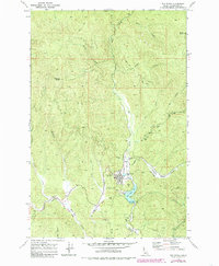
1969 Map of Elk River
USGS Topo · Published 1985About this map
The town of Elk River serves as the hub of this Clearwater County landscape, centered around the Elk Creek Res and its distinctive spillway. The map captures a transition in the local economy and infrastructure, notably marked by the Old Railroad Grade winding through the valley near Jersey (Site). The timber-supported heritage of the region is evident in the network of logging roads and a local Landing Strip positioned just north of the town center.
Find a feature on this map
35 named features on this map. Tap any name to fly to it.
Don’t see what you’re looking for? This feature index may not catch every label — zoom into the map to look around manually.
Map Details
Editions of this 1969 Elk River Map
2 editions found
Other maps of this area

1955 · Pullman
USGS Topo · 1:250,000

1958 · Pullman
USGS Topo · 1:250,000

1961 · Ahsahka
USGS Topo · 1:62,500

1961 · Bovill
USGS Topo · 1:62,500

1969 · Elk River
USGS Topo · 1:24,000

1969 · Elk Creek Falls
USGS Topo · 1:24,000
1969 · Elk Butte
USGS Topo · 1:24,000

1969 · Anthony Peak
USGS Topo · 1:24,000
1969 · Little Green Mountain
USGS Topo · 1:24,000
1969 · Grice Ridge
USGS Topo · 1:24,000