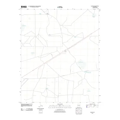
2010 Map of Elkins
USGS Topo · Published 2010About this map
The settlement of Elkins sits at the junction of US Route 70 and several county roads, serving as a primary focal point in this portion of Chaves County. This semi-arid landscape is defined by its ranching infrastructure and intermittent water sources, characterized by a series of named catchment basins and ephemeral lakes. Landmarks such as Smith Windmill and the South Chatten-Muncy Ranch reflect the area's agricultural dependency, while Little Red Lake, Samples Lake, and White Lake indicate the natural depressions that dot the terrain. The network of local routes, including Railroad Mt Rd and Llauds Rd, provides a clear view of the transportation corridors and property boundaries established by the early 21st century. This survey documents the persistent human presence and water management strategies in an environment where resources like White Lake Tank and Cocklebur Tank are essential to local operations.
Find a feature on this map
21 named features on this map. Tap any name to fly to it.
Don’t see what you’re looking for? This feature index may not catch every label — zoom into the map to look around manually.
Map Details
Editions of this 2010 Elkins Map
This is the sole edition of this map. No revisions or reprints were ever made.
Other maps of this area

1954 · Brownfield
USGS Topo · 1:250,000

1955 · Roswell
USGS Topo · 1:250,000

1958 · Brownfield
USGS Topo · 1:250,000

1958 · Roswell
USGS Topo · 1:250,000

1962 · Roswell
USGS Topo · 1:250,000

1962 · Brownfield
USGS Topo · 1:250,000
1967 · Campbell
USGS Topo · 1:24,000

1967 · Haystack Mountain
USGS Topo · 1:24,000
1967 · Haystack Butte
USGS Topo · 1:24,000

1967 · Elkins
USGS Topo · 1:24,000