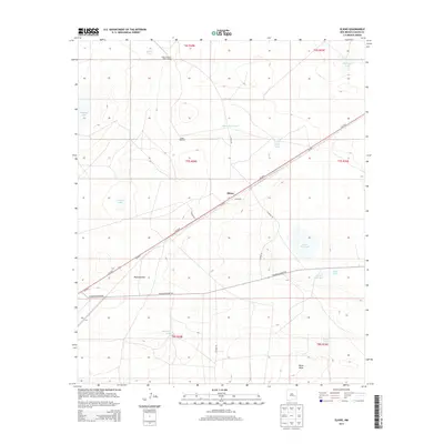
2013 Map of Elkins
USGS Topo · Published 2013About this map
Elkins is a small settlement and transit point in New Mexico's eastern plains, bisected by the diagonal route of Us-70. The landscape is defined by its arid cattle ranching heritage, featuring isolated homesteads like the South Chatten-Muncy Ranch and vital water infrastructure including the Smith Windmill and Elkins Water Tank. Scattered across the terrain are numerous ephemeral basins and tanks such as Johnson Lake, Samples Lake, and Little Red Lake, which historically provided the essential water supply for livestock in this high-desert environment. Geologically, the area transitions from the prominent ridge of Railroad Mtn to the rising land of Palma Mesa in the southeast. This survey details the remote layout of township boundaries like t7s r28e and the gravel corridors of Railroad Mount Rd, illustrating the intersection of modern transportation with traditional high-plains ranching life.
Find a feature on this map
26 named features on this map. Tap any name to fly to it.
Don’t see what you’re looking for? This feature index may not catch every label — zoom into the map to look around manually.
Map Details
Editions of this 2013 Elkins Map
This is the sole edition of this map. No revisions or reprints were ever made.
Other maps of this area

1954 · Brownfield
USGS Topo · 1:250,000

1955 · Roswell
USGS Topo · 1:250,000

1958 · Brownfield
USGS Topo · 1:250,000

1958 · Roswell
USGS Topo · 1:250,000

1962 · Roswell
USGS Topo · 1:250,000

1962 · Brownfield
USGS Topo · 1:250,000
1967 · Campbell
USGS Topo · 1:24,000

1967 · Haystack Mountain
USGS Topo · 1:24,000
1967 · Haystack Butte
USGS Topo · 1:24,000

1967 · Elkins
USGS Topo · 1:24,000